


Follow The Voyage: The Kimberley Cruise
Broome to Broome | 8 April 2022 – 18 April 2022
Master: Miles Hammond Expedition Leader: Melanie Faithfull Assistant Expedition Leader: Emily Fosebery Expedition Crew: Dawn Singleton, Karla Pound & Meg Vaisey Guest Lecturers: Sandy Scott & Ian Herford
Jump To: Day 1 | Day 2 | Day 3 | Day 4 | Day 5 | Day 6 | Day 7 | Day 8 | Day 9 | Day 10
VIEW ITINERARY & FARES VIEW BROCHURE
DAY 1: DEPARTING BROOME
8 April 2022
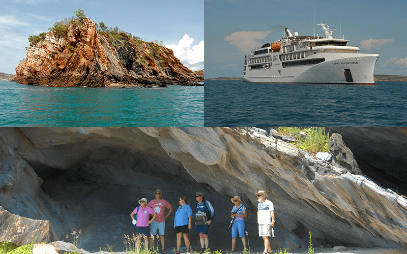
Once we arrived at the Civic Centre, there were many eager guests ready to check in. Before long, all guests were checked in and all luggage had been tagged. The team worked effectively to hand out Rapid Antigen Tests and assisted with explaining the process to each table. Once all tests were negative, we boarded the buses and headed to Coral Adventurer. After guests embarked, the team delivered all luggage to guest rooms then prepared the bridge deck lounge for the muster drill. Overall, a very successful embarkation day for CA.
DAY 2: IRON ISLANDS & NARES POINT
9 April 2022
After breakfast, all guests were gathered in the Bridge Deck Lounge for an introduction to the expedition team and itinerary for the trip. This was followed by a briefing on the helicopter flight over Mitchell Falls. We had around 47 guests sign up for the optional flight. At 10:30am guests enjoyed morning tea. After morning tea, Sandy gave his first talk which was an introduction to the Kimberley which got the guests all excited for what is to come.
At 2:00pm, our first Xplorer departed to cruise through Nares Point and the Iron Islands. Although it was warm, for our first expedition it was enjoyable on all accounts. The ocean was calm, the deep blue colours a beautiful contrast to the reds of the land we saw. We made a landing at Nares Point where guests were able to relish in astonishing geology. For first time Kimberley guest lecturer Ian, we had to basically drag him off the beach. Being a Geologist, he was amazed and stoked. And even better, guests were thrilled with the energy and excitement he brought to the excursion. Brahminy Kites soured above and Kimberley Honey eaters flew throughout the trees. After jumping back on the Xplorers, we cruised down through the Iron Islands before returning to Coral Adventurer. Captain’s Welcome drinks began upstairs at 6:00pm, with a beautiful sunset to follow.
DAY 3: PRINCE REGENT RIVER & CAREENING BAY
10 April 2022
Guests enjoyed an early breakfast before we departed on the Xplorers down the Prince Regent River. As we left, the sun began to rise over the horizon. It was a beautiful calm morning, reflections highlighting the iconic Kimberley sandstone. As we cruised down the calm river, a small pod of snubfin dolphins traveled ahead of us. We stopped just before we could see the falls, but we could definitely hear them. Our Xplorers entered King Cascade to see water cascading down the fall, a joyful sight for all. We nosed the Xplorers under the falls so we could cool off in our first Kimberley shower. It was a delightful feeling after a warm first few days being in the Kimberley. After a few dunks, we began our ride back down the mill pond Prince Regent River.
Guests had lunch back on board at 11:45am. At 2:00pm, Guest Lecturer Ian presented his first talk on Geology. Outside we saw the views of the coastline as we traveled out of St George Basin on our way to Careening Bay. His presentation was great; very engaging and interesting. He definitely makes geology very cool.
We left for Careening Bay a little later in the afternoon than normal. This seemed to work well as it was slightly cooler at this time. Sandy led our first group over to Careening Bay. We stopped to have a look at the Cycads at the end of the beach. The grass was tall as guest embarked along the track towards the valley, it was like a true expedition. We stopped to see the bower of the bower bird hidden amongst the trees. Ian, Dawn and Emily led the second group. Ian told the historical story of the careening of the Mermaid, whilst Dawn did some interpreting on the flora and a little beach comb. Considering it was a warm day, everyone seemed in good spirits on our way back to the ship. We were back on board by 5:30pm, before heading to pre-dinner drinks at 6:00pm. Everyone enjoyed their nice cold beverages after a long and eventful day. Guests had dinner, followed by Meg hosting a games night with a decent turn out. They played a game of charades. As always, it was a laugh.
DAY 4: VANSITTART BAY
11 April 2022
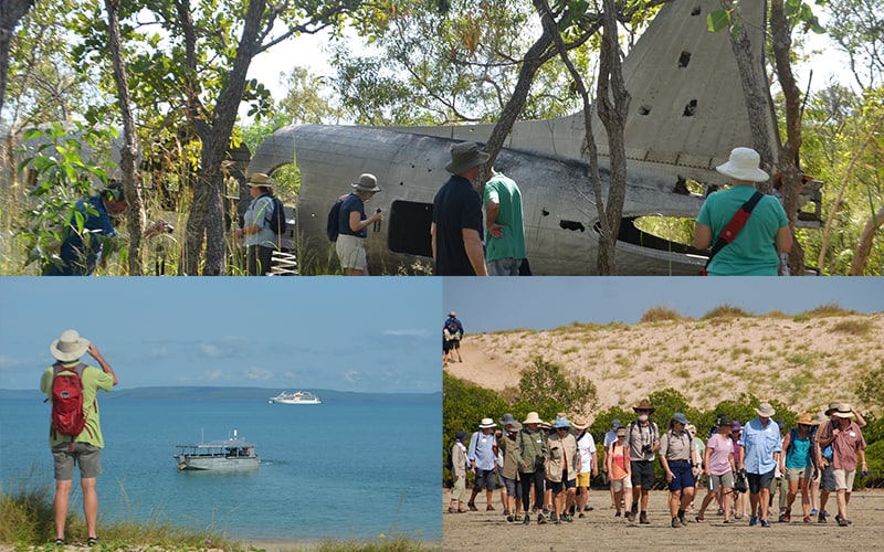
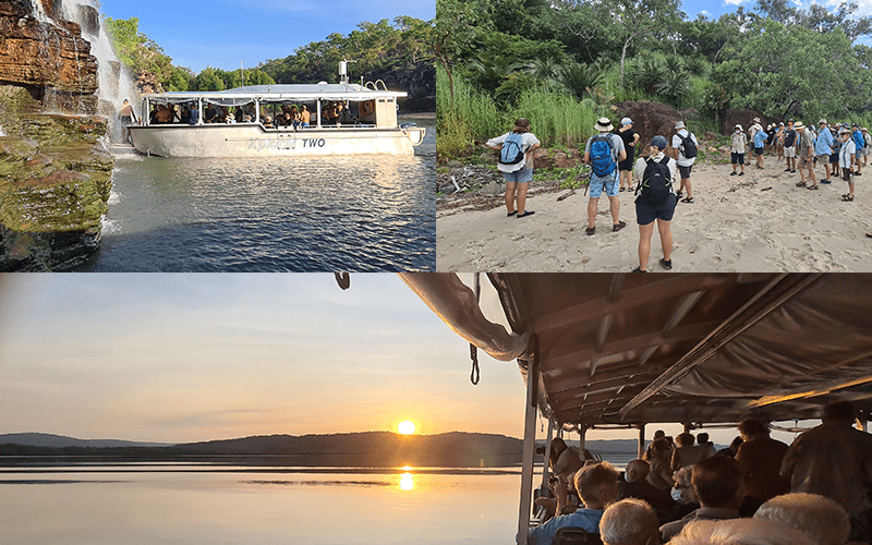
We started the day off with a relaxed morning on board and breakfast at 8:00am. We departed at 09:45am to view the C53 plane wreck. It was a very hot morning, but everyone made it up over the dune and across the plain to the wreck site. We stopped to watch the elusive fiddler crabs scatter into their holes, waiting for the tide to flood the plain. Honeyeaters flew and chirped amongst the trees as we walked around the wreck site. The story of the plane wreck was shared with guests and we viewed the boab tree and termite mound. Harry brought the Xplorer back over early so that guests could get some shade and rest their legs. Both groups were back on board the air-conditioned Coral Adventurer by 11:30am, excited for a cold shower.
At 2:00pm, we departed for our afternoon activity to see the Gwion Gwion rock art at Jar Island. We were prepared for another warm afternoon. One group went straight to the art sites whilst the others went for a short cruise then a walk through the mangroves, and then we swapped. We decided to offer the option of a cruise on both Xplorers for those who don’t want to venture into the warm sun again. On the cruise, Meg did a talk on pearls as we drove past the pearl farm. Everyone loved it. We split the groups up to view the different sites, trying to keep in the shade as much as possible. Despite the heat, everyone powered through.
Guests were in awe of the remoteness of the art, disguised amongst the marbled rocky outcrops. We organised multiple transfers back to the ship throughout the afternoon. Once back on board, BBQ night was hosted by hospitality on the Vista Deck. It seemed a relief for guests to enjoy some cold beers and a relaxed dinner after a big day. A beautiful sunset lit up the sky behind everyone as they ate, a perfect end to another awesome day. After dinner, the documentary ‘Riddle of the Bradshaws’ played for those who wanted to learn more about the rock art in the Kimberley.
DAY 5: KING GEORGE RIVER
12 April 2022
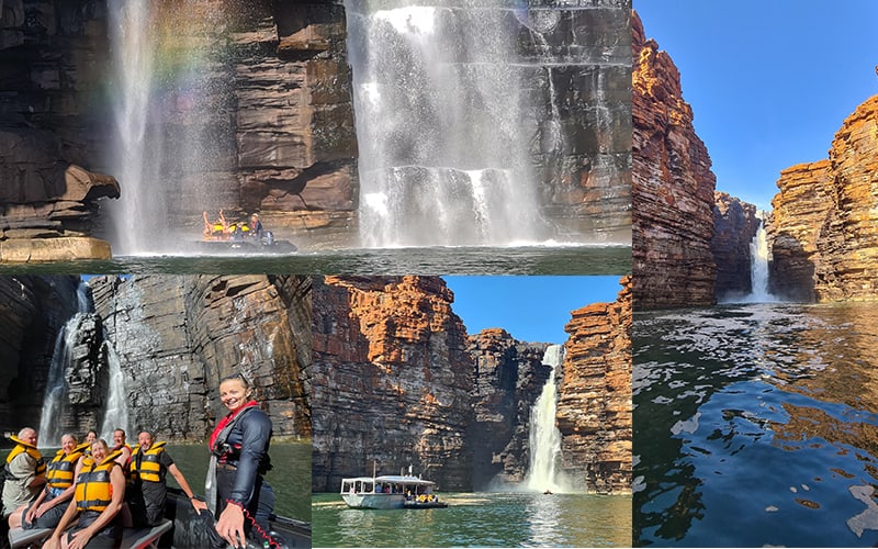
After breakfast at 07:45am, we departed for King George River at 09:00am. Guests were all very excited to see the mighty falls at the end of the river. The first Xplorer headed straight for the falls whilst the second Xplorer slowly cruised down to allow enough time for the first group to have a dip under the water. On our way down, we stopped by the shallow mangroves to discuss the habitat and environment within the river. Ian explained to the guests how the shallow sandy bank has allowed seagrass beds to grow, which bring along our evasive mammal friends, the dugong. As we slowly cruised by, almost on cue, we spotted a dugong quickly come up to the surface before submerging. Being the shy creatures they are, unfortunately that was all we would see. We stopped to talk about the geology and the interesting tafoni that occurs along the towering walls. It was a happy site as we turned the bend at the end of the river to see the twin Oomari falls flowing.
We began to transfer guest into zodiacs for a closer look under the falls. Everyone was eager to get right up and under the falls and marvel at the sheer height of the cliffs. For those that remained on board the Xplorers, we cruised between the twin falls getting close enough to feel the spray of the water, just enough to cool everyone down.
Both Xplorers returned by 12:00am. After lunch, Sandy presented his talk on ‘Visitors, Discovery and Charting’ which went a little more in depth into the Indigenous groups of Kimberley and the naming of new discoveries. After an afternoon tea break at 3:00pm, Ian presented his next talk on ‘Giant Animals of the Kimberley coast’. It was very interesting and very relevant to the remote Kimberley environment with insight into the history from way back when dinosaurs roamed.
At sunset drinks, Sandy explained the relevance of the rainbow serpents of the Indigenous Dreamtime and their relation to making rivers, such as the King George. After dinner, guests enjoyed a screening of the documentary relevant to our day’s adventure, ‘The Koolama Incident’.
DAY 6: WOLLASTON & BIGGE ISLAND
13 April 2022
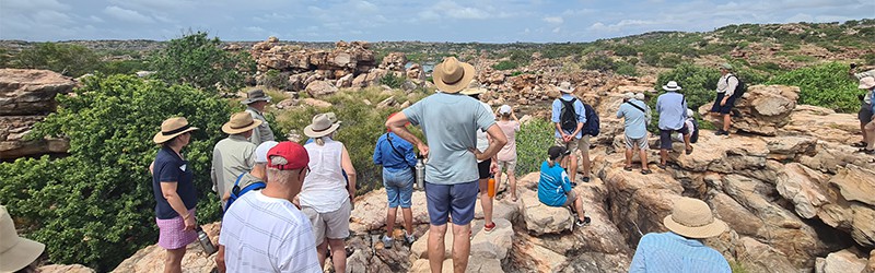
This morning we anchored near ‘Veranda Beach’ at Wollaston Island then were taken by Xplorer to a relatively new (to Coral Expeditions) art site. This location required a short rock scramble but turned out to be an extensive open cave site with many Wandjina images. One that attracted Sandy’s attention was the largest and most complete Wandjina which over-painted a long polychrome straight-part image with an unusual headdress. This red outlined figure had yellow infill. Other rock art styles in the large cave area included rock pecked images (petroglyphs).
After this exciting visit we sailed around the island, looked at the remains of a dolerite sill, saw patches of monsoon rainforest and palms, and noted an osprey nest and its two resident owners before returning to CA for morning tea.
Before lunch Sandy gave an illustrated talk about rock painting styles across Northern Australia and some details about what we would be seeing during our current Kimberley cruising. This talk covered both ancient and modern-day expressions stretching from the north of Queensland’s Cape York, across Arnhem Land and Kakadu to the Kimberley. He mentioned the range of Kimberley styles and gave an indication of when these were likely to have been part of the culture.
After lunch we had arrived at Wary Bay on Bigge Island ready for the first group to cruise across to the beach. We divided into two sub-groups one looked at the rock paintings and while one went to see the ceremonial site and the local vegetation before returning to the art sites. From this high location used to see the stone ceremonial site we climbed down to the hummock grass covered sand plain then along the walk next to the mangroves. This plant community may have served as a larder when traditional families lived on the island offering crabs, a range of shellfish, worms, medicines, and wood for burning and tools.
We then climbed up to the sand plain past a huge rock fig tree and an Owinia sp.(emu-apple) tree to the cliff face to see the what the slot cave, the overhangs and the caves held to offer: the slot cave had been used as a secondary burial site for humans, the first overhang held the painting of the Father Kaiara (the name for important coastal Wandjinas) and two other Wandjina figures. The next cave held the nearly rubbed-off contact art image of three men in a boat and the last largest cave held a variety of images including-the five sailors with their pipes and water bottles. This cave also contained a monjon painting, a red ochre painting of the Wandjina with the long genitalia who controls storms at sea, several handprints, and a pearling lugger.
Overnight we steamed (to use a nautical term) to Prince Frederick Harbour using our regular electric motors.
DAY 7: PRICE FREDRICK HARBOUR & HELI dAY
14 April 2022
Well before daylight we were anchored near Naturalists Island at the rear of Prince Frederick Harbour ready for the first helicopter departure at 8am. Our first cruise was to Lumbarni Island to see the image of Lumbarni a local Wandjina and of significance to the Gambera clan that used to live near here.
The image was under a small rock overhang surrounded by beach spinifex and a Terminalia tree and protected from the sea by a large mass of rock. On the seaward side of the mass were able to crawl into the centre of these large rocks and see it was connected to the tidal water and had a mangrove population of club mangrove (Agialitis annulata), grey mangrove (Avicenna marina) and a small proportion of myrtle mangrove (Osbornia octodonta).
From Lumbarni we sailed across to the north of the Harbour to see a fascinating rock structure Thor’s Hammer. This unusual structure had a handle of crushed up rock (called breccia) that was held together by quartz and veins of quartz. The hammer head was a huge block of Wunaamin Milliwundi Sandstone. After many photographs we returned to CA for lunch.
During the afternoon we took the Xplorer up the Hunter River and on the way I related the origin of the Roe and Hunter River names and told the interesting story about King and his team lunching on Hall and Donkin’s canned meat. This led to the naming of Donkin Hill near the upper Hunter River by King in 1820. During the cruise we saw examples of deciduous (vine thicket) rainforest on westerly facing scree slopes and semi deciduous rainforest patches in small valleys facing southward.
We also saw that many of the small headlands around the Harbour and river were formed from Hart Dolerite and that they were quite rounded and mostly vegetated with grass. Elsewhere there were blocky Sandstone cliffs with rough scree slopes where eucalypt woodland dominated. I explained how relatively rapid weathering of Hart Dolerite intruded in the King Leopold Sandstone had resulted, after long geological periods, in the opening-up of Prince Frederick Harbour and how this was aided by the Hunter and Roe rivers.
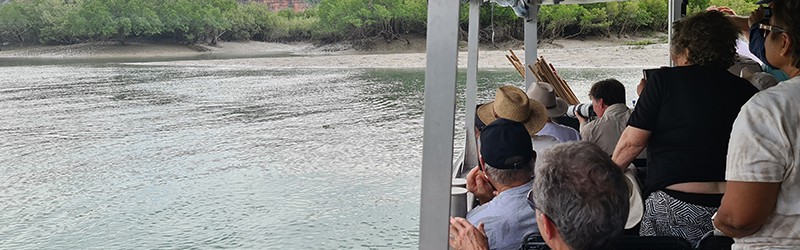
Once we reached Porosus Creek many people transferred to the Zodiacs to explore the mangal (another name for a mangrove community) on the west side of the creek. This mangal is dominated by Stilt Mangroves with large trees of white-flowered apple mangrove lining much of creek side. Kapok mangrove lined many of the channels off the main creek. Club mangrove formed a pasture-like cover on several open, mid-tide mud flats. Many of us saw the mudskippers and the red fiddler crabs on the exposed mud banks, and we were delighted to see at least three ‘salties’ (Indo-Pacific Crocodile).
We all saw the tangle of looping aerial roots on the stilt mangrove, and I explained their function in gaseous exchange for the roots. The upright stout aerial roots around the apple mangrove and the thin pencil-like roots on the grey mangrove served the same function -officially this kind of root is called a pneumatophore. Remember the roots of these plants are in water saturated soils with literally no oxygen.
DAY 8: FRESHWATER (WINJINGARRA BARD BARD) & MONTGOMERY REEF
15 April 2022
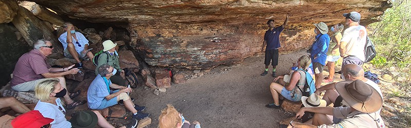
We sailed across to Freshwater in three separate sub-groups and were all greeted and welcomed to country by Naomi, with stripes of ochre on either cheek. The walkers then set off up the hill to see Cyclone Cave with Neil.
The long hill slope dipped under the sea and is formed of Pentecost Sandstone. At the top of the hill is a cliff cut down at right angles (geomorphologists call this slope and cliff a cuesta) and at the base of the sandstone lies the over the fragile Elgee Siltstone formation rock. The siltstone has been naturally weathered and eroded to form a line of caves under the Pentecost Sandstone. One of these caves served as an archaeological dig site and the one we visited has been used as a shelter and as rock painting ‘art gallery’
People who did not go to the cave spoke with Naomi and her daughter in the wide, covered, but open painting area. Here Naomi explained the meaning of their traditional name Winjingarra Bard Bard and how the name describes the northern spotted quoll and how the quoll shook itself when it emerged from the water.
After lunch Ian presented ‘Geology of the Kimberley Region’ where he covered the origins of the main rock formations and how they had developed across the gradually sinking Kimberley Basin. He also covered some of the extra-terrestrial events such as Wolf Creek crater and how this had formed in the southeast Kimberley. Ian concluded with several examples demonstrating the sound knowledge Traditional owners had re geological variations for tool making materials and via ochres.
From our anchorage near Wijingarra we made our way out to anchor near Montgomery Reef during the afternoon. Our Xplorer excursions were timed to see the effect of a dropping tide that had begun after midday. We hoped to see the reef emerging -a goal that was superbly achieved!
On the Xplorer we gave some dimensions of the reef (just under 400km2) and how and when the reef is exposed by tidal movements. I mentioned past Aboriginal use of the reef and how the ‘tide riders’ used the currents to bring their rafts out to the reef islands and to High Cliffy Island. High Cliffy Island had a permanent clan, the Jaudibala, who lived here until the late 1920s.
During our excursion Mel and I explained there is a wide variety of small hard green, blue, aqua, and purple corals of varying shapes and surface patterns dispersed among several species of brown seaweed, sand patches, sea grass and broken lumps of coral on the reef. In addition, there are anemone, sponges, sea squirts, clams, tube worms, crabs, brittle stars, and small fish living in pools all over the reef. From the Xplorer we watched the gushing streams spill off the reef amongst continuous spotting of turtles coming to the surface to breath as we cruised along the ‘river’.
Recent research has shown that one of the significant reefs building organisms are tennis ball sized lumps of calcareous red algae known as Rhodoliths. Researchers have shown that the reef was its initial development on top of an old mesa as the sea levels stabilised 6000 years ago. When we sail up the canal/river into the edge of the reef we are following an original ravine in the side of the mesa (a flat-topped hill). For this structure there are no signs of horizontal growth via a fringing reef development around the perimeter. It appears that the natural ‘rubbish’ from the reef organisms, including a high proportion of living Rhodoliths, have accumulated around the reef perimeter to form the rises enclosing the two large lagoons we saw on either side the river.
We enjoyed drinks as we watched the reef emerge and left at 6.00pm about half an hour before low tide. Our ride home was exciting especially as Louis brought us across for loading.
DAY 9: TALBOT (CYCLONE) CREEK & HORIZONTAL WATERFALLS
16 April 2022
Our Talbot Creek excursion started with a search for short eared rock wallabies but the family that was here has disappeared or they remained hidden in caves to stay cool. We had looked on the lower edge of the Pentecost Sandstone hill but with no luck. The channel led up into a lagoon where the company who flies people in to see the falls had their base. Originally this area was also utilized by the cultured pearl farm that once use Talbot Bay to grow their pearl shells to protect gear during cyclones.
The dramatic colours and shapes along the Talbot Creek were outstanding with the towering cliffs of Pentecost Sandstone, the conglomerate -dominated ridge of Elgee Siltstone and Warton Sandstone ridge. We passed through a gap in the Pentecost Sandstone into and open embayment that had once been filled with Elgee Siltstone now long but left a few remnants. One remnant was finely bedded folded rock remaining on a wall, but the other was ridge of conglomerate that dominated rock lining one side of the creek/estuary channel. On the other side of this channel was a sloping ridge of Warton Sandstone.
We saw few birds, but many species of eucalypts and a few specimens of northern cypress pine (Callitris intratropica) perched on a ridge. Most of the shorelines of this estuary were lined with a gallery of mangroves. Because of the low tide condition, we could not reach the gap in the Warton that led to another embayment formed in the past after the removal of the Carson Volcanics by weathering and erosion. We were told that most of this embayment is filled with tidal channels connected to Talbot Creek and masses of mangroves. As we returned to the ship at anchor in Talbot Bay, we had time looking at the mud banks and the many red fiddler crabs (Uca flammula) on mud near the root systems of kapok mangrove and grey/white mangrove. Our Xplorer was also able to see a small floating crocodile.
After returning to CA it was time for morning tea and for those going on a Bridge tour. By mid afternoon conditions were deemed to be safe to begins rides up and down the waterfall. Most people forgot about the geology(!!)and but engaged with the excitement.
DAY 10: ARRIVING BROOME
8 April 2022
Ian began the day with a presentation ‘Managing our National Parks’. Using the park based around the Mitchell River Falls he pointed out the criteria for the park’s existence and the regulations that surround it operation. One of the points that stimulated questions and answers by Ian related to the control of non- indigenous plants and animals particularly the problem of feral cats and the cane toad.
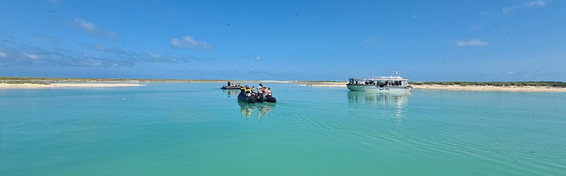
At the end of Ian’s talk we were called to join the Xplorers for our experience at the Lacepede Islands. The four Lacepede Islands are over 25 km from Dampier Peninsula sitting in the Indian Ocean and designated as an A Class Reserve. They are formed from sand derived mainly from, crushed coral and it is the two western most islands (Middle and West) that we had to sail between to reach a lagoon to their south. Once in the lagoon the spectacular display of many bird species began especially, we drifted into the extensions of the main lagoon on the Xplorer of on the Zodiacs.
The most prominent bird species was the brown booby and a few of these had produced chicks some of which were fluffy white and as big as their parents. Some of the other species we saw included the Australian pelican, pied oyster catchers, common noddies, eastern reef egrets, ruddy turnstones, Caspian terns, crested terns, silver gulls, lesser frigate birds, pied cormorants, and a number of wader species. We also saw innumerable green turtles and shovel-nose rays. Today I added to my list with black tipped reef sharks and the largest shovel-nosed ray (probably a metre long) I have seen
During the morning I talked about the naming of the Island by Nicolas Baudin in 1802 and the collection of over 20,000 tons of guano (solidified bird droppings from sea birds) between 1876 and 1891and how much of this guano was exported to Mauritius and Germany to be used as fertilizer.
After lunch we began our journey south to Broome Port.
We finished the day with more engine room tours then cruise reviews with the Expedition Team.